This website has been automatically translated by DeepL. When accessing the pages, personal data remains anonymous, as no data is transmitted to the service provider. The translated content is stored locally on the City of Bonn's web server and delivered directly from there. However, it is possible that machine translations do not fully correspond to the original text. The City of Bonn therefore accepts no liability for the accuracy, completeness and up-to-dateness of the translations.
We use cookies to ensure that we give you the best experience on our website www.bonn.de. Technically necessary cookies are set for the operation of the site. In addition, you can allow cookies for statistical purposes and thus help us to constantly improve the user-friendliness of bonn.de. You can adjust the data protection settings at any time or agree to all cookies directly.
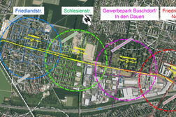
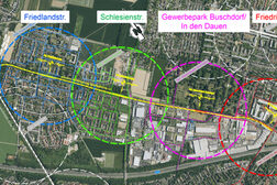
The light rail line is being extended in the north of Bonn. In future, it will run from Tannenbusch through Buschdorf to the Nordfriedhof cemetery.
The detail shows Buschdorf and the planned extension of the light rail line.
In future, the light rail line is to run further into Buschdorf and as far as the Nordfriedhof cemetery. The line will use the railroad line of the Rheinuferbahn, which still runs through Buschdorf today and has not been built on. On the northern edge of Buschdorf, a new connecting curve will link the current light rail line from the Buschdorf stop with the new line in the district.
Four new stops
Thanks to the extension, local transport in the north of Bonn will be significantly strengthened. In future, the light rail line will connect the Buschdorf industrial park as well as the center of Buschdorf. Stops are to be built in the area of Friedlandstraße, Schlesienstraße, the Buschdorf business park and Friedrich-Wöhler-Straße (Nordbahnhof). The streetcars that currently terminate in Tannenbusch-Mitte will then use the new route all day, every day, and will be able to transfer to the existing bus routes at all four new stops. The journey time from Bonn Central Station to the planned new stops will be approximately halved compared to the current bus connection.
The costs are estimated at around 31 million euros (2016 prices). According to an independent analysis, up to 4,200 passengers per day will use the new connection. As the population in the north of Bonn is growing, a higher number of passengers can be expected in the future, as Buschdorf is a growing district. Various projects are to be implemented in the coming years, first and foremost the sustainable, climate-neutral and car-free residential district "Im Rosenfeld", including a daycare center and elementary school. Other planned neighborhoods include Otto-Hahn-Straße/Kölnstraße and Schlesienstraße (Godau-Gelände/Petrusacker), which will benefit from a direct connection to the light rail extension.
The climate-friendly rail link can therefore make an important contribution to relieving congestion on Bonn's roads.
Current status of the project
On January 15, 2025, the extension of the light rail line to Buschdorf/Auerberg was included in the public transport requirements plan and the public transport infrastructure financing plan by the Transport Committee of the state of North Rhine-Westphalia. This means that funding for the measure is possible in principle.
The regional council of the Cologne administrative district proposed the inclusion of the light rail project in the NRW public transport requirements plan and the public transport infrastructure financing plan at its meeting on October 11, 2024. Prior to this, the city administration had completed the preliminary planning and the results of the standardized assessment. The assessment resulted in a positive benefit-cost factor of 1.4, meaning that the benefits of the new connection for the general public are greater than the necessary investment costs.
A standardized assessment answers the important question of whether a project makes economic sense. Economically viable means that the costs and benefits of a project are considered for the general public - i.e. not only the consequences for individual groups such as residents or commuters, but also, for example, environmental consequences that affect everyone. On the other hand, a standardized assessment is the basis for the city to apply for funding from the state and federal government under the Municipal Transport Financing Act (GVFG) to finance the infrastructure.
In September 2020, the Bonn City Council commissioned the city administration to carry out all planning, technical and legal steps, a cost-benefit analysis and a standardized assessment as a matter of priority. A possible extension of the light rail line to Auerberg and/or the streetcar line 61 towards Buschdorf, which currently ends at the corner of Pariser/Kopenhagener Straße, should only be pursued as an option afterwards.
Participants' ideas and suggestions for extending the light rail line.
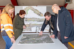
Dialogue event with residents
On Saturday, March 29, a dialog event on the extension of line 63 took place at the Am Apfelgarten elementary school. Residents along the route and interested citizens were invited to discuss the project with external and municipal experts. After a welcome address by Mayor Katja Dörner and Anja Wenmakers from SWB, the project was presented. Participants were then able to discuss specific areas of the project at four themed islands. Citizens had the opportunity to express their ideas, suggestions and concerns on the spot. From these contributions, the city administration compiled a list of the most important questions and answers. Most of the participants' questions revolved around the topics of noise protection, the situation at the level crossings, the location of the stations and the cost-benefit analysis.
FAQ: Frequently asked questions and answers about the light rail extension to Buschdorf
What measures are being taken to protect residents from noise?
Noise protection is regulated by the Federal Immission Control Act. The 16th Federal Immission Control Ordinance contains specifications regarding the maximum noise level depending on the use of the area. In the upcoming planning phase of the light rail extension, the noise emissions will be calculated using the relevant calculation regulations and compared with the limit values. In general, emissions should be kept as low as possible. This can be achieved, for example, by a straight route, a route in a cut (possibly in combination with a noise barrier) and external platforms that shield the noise in the rail-wheel area.
What is the situation regarding safety and traffic flow at level crossings?
The existing level crossings at Friedlandstraße, Otto-Hahn-Straße, Schlesienstraße, In den Dauen and Friedrich-Wöhler-Straße will continue to be used. The barrier closing times are to be limited to what is absolutely necessary in order to maximize the opportunities for crossing the light rail line and also access to the platforms.
The level crossings will be technically secured to the current standard. The roadway will be secured by means of half barriers, while the side footpaths and cycle paths will be secured by means of full barriers. There will also be appropriate light signals and the necessary signage. For children, additional light signals will be installed at a child-friendly viewing height. For visually impaired people, the level crossings will be equipped with tactile guidance and appropriate acoustics will be installed.
The level crossings will be optimized in terms of barrier closing times. As part of the design planning, appropriate traffic routing in the vicinity of the level crossings will also be considered in more detail in order to keep traffic disruption to a minimum. Compared to traffic signal-controlled crossings, the overall impact of level crossings is estimated to be lower, as the "closure times" are significantly shorter.
Is the location of the four stations fixed and are three stations not enough?
The four stations resulted from the feasibility study and the preliminary planning, whereby several variants were examined. The variant with four stops on the route between the existing Buschdorf light rail stop and the planned Friedrich-Wöhler-Straße/Nordbahnhof terminus has been planned in such a way that all users (both from the residential areas and the business park) are optimally connected. The original specification from the political committees envisaged the Friedlandstraße/Otto-Hahn-Straße/Schlesienstraße/Friedrich-Wöhler-Straße stops on the shorter section between the existing Buschdorf light rail stop and the Friedrich-Wöhler-Straße terminus at the south-western tip of the Nordfriedhof cemetery. In contrast, the distances between stops have already been increased, especially in the residential area. A further reduction or consolidation of the Friedlandstraße and Schlesienstraße stops is not planned due to the resulting longer access routes, as the travel times, which also include the access times to the stops, would be significantly longer as a result. The location of the stops was also considered with regard to future urban developments.
What is the frequency of the future line on weekdays and at weekends?
A 10-minute interval is planned for the line extension in both directions. The frequency will be reduced to every 15 minutes in the evening and every 30 minutes in the late evening.
How long will the work on the route take?
As things stand at present, construction is expected to take around three years in total. There will be various construction phases so that construction will not take three years at every point along the route.
How much will the line extension cost?
In accordance with the specifications of the standardized evaluation, the costs were estimated at 31 million euros net as of 2016. It is possible that 90% of the eligible construction costs will be subsidized by the state of North Rhine-Westphalia and the federal government. Accordingly, the annual operating costs amount to 640,000 euros and the annual maintenance costs for the infrastructure are 300,000 euros.
How many public parking spaces will be lost?
Since mainly current and former railroad areas as well as public and private green spaces and agricultural areas are used, public traffic areas are only affected to a small extent.
What will the stations look like and what services will they offer?
The light rail stops are based on the current design of existing light rail stops in the SWB Bus und Bahn network. There will be facilities for parking bicycles at each stop. The positioning of other mobility options will be examined as the planning progresses. This also includes equipping the stops with seating, lighting and planting.
Has access to the individual stations already been determined?
Access to the individual stations is largely determined by the location of the level crossings and the paths parallel to the railroad. The planning of the possible access points will be considered in more detail in the further course of the planning process.
Do the tracks and track bed have to be renewed or can existing track surfaces be used?
In principle, the track bed of the existing siding could continue to be used, as the track is designed for much higher axle loads. Due to the double track required for light rail operation, the subgrade (area for track superstructure with track ballast, sleepers and rails) for the track bed must be widened, the alignment must be adapted to the requirements and appropriate track drainage must be ensured. For this reason, the existing track bed cannot continue to be used unchanged and will probably have to be removed in order to construct the track substructure and the track drainage system and to be able to rebuild the superstructure with the tracks on top. The existing tracks have not been maintained by Häfen und Güterverkehr Köln AG for more than ten years, meaning that the wooden sleepers are largely no longer suitable for further use and a new track superstructure with ballast superstructure, sleepers and rails will be constructed.
What additional space is needed for use?
Existing or former railroad areas are to be used primarily for the light rail extension. In some cases, areas currently used for agriculture are also being sought.
To what extent are playgrounds affected by the measure?
Playgrounds are not directly affected by the measure. If necessary, a new, secure boundary between the track area and adjacent public traffic and green areas will be created to prevent free access to the track area and thus also contribute to the safety of children at play.
Will SWB's new Skoda streetcars be used on the new route?
As line 63 is a high-floor urban line, the new streetcars cannot be used. However, if a connection is made with the rail network of line 61, the new streetcars could also run to Buschdorf.
What investigations are being carried out in advance for the light rail extension?
Environmental concerns are examined in advance. This includes the preparation of a species protection report, as part of which the route is examined for protected species and plants. Furthermore, an accompanying landscape conservation plan will be drawn up, in which the impact on nature and the landscape will be described and appropriate compensatory measures proposed as compensation.
Investigations are also planned for the area of noise and vibrations, so that the proportion of noise induced by the light rail at the immission points can be determined on the basis of the topography and taking into account adjacent land uses. If limit values are exceeded, appropriate measures are proposed close to the point of emission. In general, emissions should be kept as low as possible. This can be achieved, for example, by a straight track layout, a track layout in a cut (possibly in combination with a noise barrier) and external platforms that shield the noise in the rail-wheel area. Further preliminary investigations include the load-bearing capacity of the ground and an aerial photo evaluation for explosive ordnance by the explosive ordnance clearance service.
How many trees need to be felled?
As part of the design planning, an accompanying landscape conservation plan will be drawn up, for which the existing fauna and flora, including the trees, will be recorded. Only after the mapping and assessment by the engineering firms involved can a statement be made on this.
How can rescue routes for the fire department, police and ambulance be guaranteed?
The rescue routes are not affected by the light rail extension, as the existing track of the connecting track or the former at least double-track Rheinuferbahn of the Köln-Bonner-Eisenbahn is mainly used.
Drone flight over the planned route
Um die einzelnen YouTube-Videos zu sehen, müssen Sie hier die Datenschutz-Einstellungen freigeben.