Find out here about the official city map, the topographical and thematic maps and the aerial photographs of the entire Bonn city area. All maps can also be ordered from the Office for Land Management and Geoinformation.
Ticket order
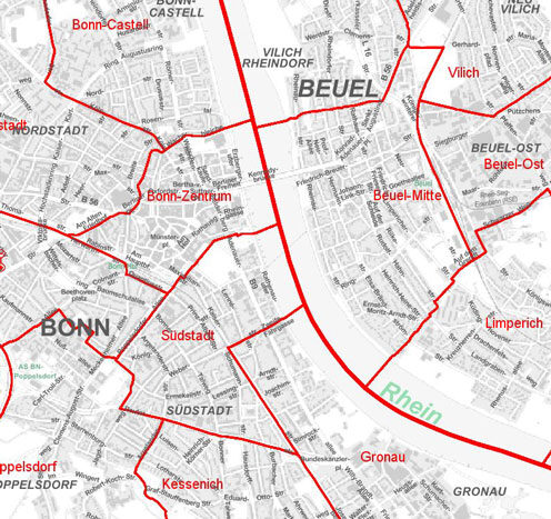
Official city map

The official city map of the City of Bonn, published by the Office for Land Management and Geoinformation, provides homeowners, non-local residents, local historians or simply citizens of Bonn interested in maps with an up-to-date, official, cartographic quality product.
In addition to the main map at a scale of 1:12,500, the city map also contains enlarged map sections of the four district centers of Bonn, Bad Godesberg, Beuel and Hardtberg as well as the federal district. It is supplemented by a district and sub-district overview and a regional map.
It shows the entire road network with all of Bonn's official street names, but also street names that are only popularly known, as well as the entire public transport network (buses and trains), bridle paths, nature conservation boundaries and much more.
In addition to the current street directory, the enclosed information booklet also contains interesting facts about the city area in brief, general information and a selection of the associations, organizations and authorities shown on the map, as well as all the schools and kindergartens in Bonn.
The official city map is supplied folded in a map sleeve. However, an unfolded version is also available, which is ideal for hanging on the wall.
In addition to the official city map at 1:12,500, there are also district maps and a tourist city map at a scale of 1:25,000.
German base map
The German Base Map 1:5,000 (DGK5) is an official topographic map series. It is one of the main map series in North Rhine-Westphalia. The urban area of the German base map is shown on 53 sheets.
Of these, 39 map sheets are processed by the Amt für Bodenmanagement und Geoinformation (Bonn working district). The 14 adjoining sheets are processed by the Rhein-Sieg district. One sheet of the DGK5 has a format of 40 x 40 cm and shows a section of 2 km x 2 km on the earth's surface.
The DGK5 forms the basis for the topographic (location-describing) maps at smaller scales.
- It can be used to depict the earth's surface and the objects associated with it in full, in the correct position and with a ground plan, in some cases generalized.
- Property boundaries (or parcel boundaries) are shown.
- The DGK5 establishes the link between the cadastral maps and the topographic maps and thus provides an overview of the natural organization of the earth's surface and the ownership structure.
- The map is extensively labeled. Depending on the edition, the elevation conditions and terrain forms are described by contour lines, and selected terrain points are provided with elevation data.
- The DGK5 is suitable as a planning document. For example, it can be used as a basis for urban land-use planning and supply facilities and the like. In addition, the DGK5 serves as a basis for surveys, documentation or evidence of various kinds.
The normal output is provided as a plot output. A plot with contour lines is also available on request. Sections can be supplied as printouts and PDF files.
Raster data
Raster data of the 1:5,000 German base map is available for the City of Bonn. One layer per sheet is available, in which the ground plan and lettering are shown.
Technical data
Resolution: 400 dpi (dots per inch)
Data format: TIFF size 1 (uncompressed), other formats on request
Data volume: approx. 5 megabytes per sheet (compressed approx. 1 to 2 MB)
Colored aerial maps

The area of the City of Bonn and the Rhein-Sieg district was flown uniformly with digital camera technology in April and May 2013 in cooperation with GeobasisNRW - District Government of Cologne, Department 7 - with the participation of the municipalities belonging to the Rhein-Sieg district.
The individual images were aligned using aerotriangulation based on the registered orientation parameters and the control points on the ground determined by GPS. On the basis of a digital terrain model, they were calculated into an orthophoto and subsequently mosaicked into an image carpet. The individual image points (pixels) have an extension of 10 x 10 cm and a positional accuracy of approx. +/- 10 cm. The rectified and geo-referenced aerial image tiles with an extent of 1000 x 1000 m can be used, for example, in geographical information systems.
In addition, data from an aerial survey from spring 2015 is available, which has a ground resolution of 20 cm, but does not cover the entire city area.
The original images are available in the UTM 32 N coordinate system. If required, they can also be provided in the "Gauss-Krüger strip 2" coordinate system. However, the images are then slightly rotated due to the georeferencing.
Thematic cards
The basis for the thematic maps is the official city map 1:12,500.
The elements of the respective theme are shown in a separate color. The maps (base and theme) are available as multi-colored prints or color plots, depending on the theme.
Available map series:
- Boroughs and districts
- District and parcel overview
- Zip code districts
- Overview of statistical districts
- Arbitration districts
- Hunting districts
- Overview of bridle paths
- Building development
- Standard land value map
- Further maps on request
For further information, please contact the Geodata Customer Center.

- Contact
- opening hours
- Location
Contact
- +49 228 772200
- +49 228 779619867
- kundenzentrum-geodatenbonnde
opening hours
- Monday, Tuesday, Wednesday and Friday 8 a.m. to 1 p.m.
- Thursday 8 a.m. to 6 p.m.
- Additional telephone service hours: Monday, Tuesday and Wednesday 1 to 4 p.m.
Location
Kundenzentrum Geodaten
Stadthaus, Etage 6 B, Raum 7
Berliner Platz 2
53111 Bonn